ESTCube-1 orbiting our colourful planet.jpg
From Spacefaring

Size of this preview: 800 × 450 pixels. Other resolutions: 320 × 180 pixels | 640 × 360 pixels | 1,024 × 576 pixels | 1,280 × 720 pixels | 3,000 × 1,688 pixels.
Original file (3,000 × 1,688 pixels, file size: 3.38 MB, MIME type: image/jpeg)
Summary
| Description |
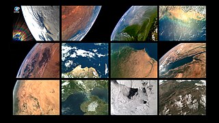
English: Compilation of photos taken by Estonian first satellite ESTCube-1 from 2013 to 2015. Showing the various colours of Earth. Starting from top left and in chronological order: Arctic; Australia; Brazil; Myanmar and Bangladesh; Algeria; Peru; Mauritania and Senegal; Red Sea; Sudan; English Channel; Antarctica; Mongolia and China. Every single image took almost a day to download, because it is 10-bit uncompressed and about 380 KB in size and has 640x480 resolution. 1 pixel is approximately 1-2 km on the ground. |
| Source | Own work |
| Author | Erik Kulu, ESTCube-1 team |
Licensing
I, the copyright holder of this work, hereby publish it under the following licence:
This file is licensed under the Creative Commons Attribution-Share Alike 4.0 International licence.
- You are free:
- to share – to copy, distribute and transmit the work
- to remix – to adapt the work
- Under the following conditions:
- attribution – You must give appropriate credit, provide a link to the licence, and indicate if changes were made. You may do so in any reasonable manner, but not in any way that suggests the licensor endorses you or your use.
- share alike – If you remix, transform, or build upon the material, you must distribute your contributions under the same or compatible licence as the original.
| This image was uploaded as part of European Science Photo Competition 2015. |
File history
Click on a date/time to view the file as it appeared at that time.
| Date/Time | Thumbnail | Dimensions | User | Comment | |
|---|---|---|---|---|---|
| current | 12:38, 30 November 2015 | | 3,000 × 1,688 (3.38 MB) | wikimediacommons>Erikkulu | User created page with UploadWizard |
File usage
There are no pages that use this file.