Geostationary Operational Environmental Satellite
From Spacefaring
Q976688
United States weather forecasting satellite series
Wikimedia, Wikidata
GOES,
weather satellite, geostationary satellite, spacecraft series, artificial satellite of the Earth, geostationary orbit, National Aeronautics and Space Administration, National Oceanic and Atmospheric Administration, United States of America, 


.png)
2022-03-01T00:00:00Z
last flight GOES-18
1975-10-16T00:00:00Z
maiden flight GOES-1
2006-05-24T00:00:00Z
2010-03-04T00:00:00Z
1975-10-25T00:00:00Z
1977-06-16T00:00:00Z
1978-06-16T00:00:00Z
1980-09-09T00:00:00Z
1981-05-22T00:00:00Z
1983-04-28T00:00:00Z
1987-02-26T00:00:00Z
1994-04-13T00:00:00Z
1995-05-23T00:00:00Z
1997-04-25T00:00:00Z
2000-05-03T00:00:00Z
2001-07-23T00:00:00Z
2009-06-27T00:00:00Z
2016-11-19T00:00:00Z
2018-03-01T00:00:00Z
2022-03-01T00:00:00Z
2024-06-25T00:00:00Z
1986-05-03T00:00:00Z
{"selectable":false,"width":"1000px","zoomMin":100000000000}
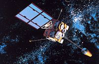
 An early GOES satellite.
 Artist's rendition of GOES D/E/F series of satellites in orbit.
 Artist's rendition of GOES D/E/F series of satellites in orbit.
 Diagram of NOAA GOES satellite data acquisition and distribution.
 Diagram of communications, data processing and dissemination associated withGeostationary Satellite System.
 Diagram of coverage of GOES satellites located over western Atlantic and eastern Pacific Oceans.
 GOES antennas Spac0197
 GOES day night picture distribution.
 GOES satellite antenna at the National Environmental SatelliteService building.
 Graphic of GOES Central Data Distribution System.
 Graphic of GOES data collection system.
 Graphic of GOES satellite data collection and distribution. Satellite shown isan Applications Technology Satellite.
 Graphic of GOES satellite data collection and distribution. Satellite shown isan Applications Technology Satellite.
 Graphic of GOES satellite operation. Satellite shown is similar to ATS seriesof satellites.
 Graphic of constellation of GOES satellites needed to view all continents exceptAntarctica. Antarctica is viewed by polar-orbiting satellites.
 Graphic showing GOES satellite data reception and image generation.Satellite shown is an Applications Technology Satellite.
 Graphic showing Geostationary Operational Environmental Satellite (GOES)Total System. Satellite shown is similar to early GOES.
 Ground communications distribution system for satellite data.
 Spac0556 - Flickr - NOAA Photo Library
 Spac0563 - Flickr - NOAA Photo Library
 Spac0576 - Flickr - NOAA Photo Library
 Synchronous Meteorological Satellite - GOES configuration.
| Type | Description | Date | Keywords | Notes | Source |
|---|---|---|---|---|---|
| link | Freebase entry@ | Wikidata | |||
| major | last flight GOES-18 | 2022 | Wikidata | ||
| major | maiden flight GOES-1 | 1975 | Wikidata | ||
| vessel | EWS-G1 | 2006 | geostationary satellite, National Oceanic and Atmospheric Administration, weather satellite | Wikidata | |
| vessel | EWS-G2 | 2010 | geostationary satellite, National Oceanic and Atmospheric Administration, weather satellite | Wikidata | |
| vessel | GOES-1 | 1975 | geostationary satellite, National Oceanic and Atmospheric Administration, weather satellite | Wikidata | |
| vessel | GOES-2 | 1977 | geostationary satellite, National Oceanic and Atmospheric Administration, weather satellite | Wikidata | |
| vessel | GOES-3 | 1978 | geostationary satellite, National Oceanic and Atmospheric Administration, weather satellite | Wikidata | |
| vessel | GOES-4 | 1980 | geostationary satellite, National Oceanic and Atmospheric Administration, weather satellite, National Aeronautics and Space Administration | Wikidata | |
| vessel | GOES-5 | 1981 | geostationary satellite, National Oceanic and Atmospheric Administration, weather satellite, National Aeronautics and Space Administration | Wikidata | |
| vessel | GOES-6 | 1983 | geostationary satellite, National Oceanic and Atmospheric Administration, weather satellite, National Aeronautics and Space Administration | Wikidata | |
| vessel | GOES-7 | 1987 | geostationary satellite, National Oceanic and Atmospheric Administration, weather satellite, National Aeronautics and Space Administration | Wikidata | |
| vessel | GOES-8 | 1994 | geostationary satellite, National Oceanic and Atmospheric Administration, weather satellite, National Aeronautics and Space Administration | Wikidata | |
| vessel | GOES-9 | 1995 | geostationary satellite, National Oceanic and Atmospheric Administration, weather satellite | Wikidata | |
| vessel | GOES-10 | 1997 | geostationary satellite, artificial satellite of the Earth, National Oceanic and Atmospheric Administration, weather satellite | Wikidata | |
| vessel | GOES-11 | 2000 | geostationary satellite, National Oceanic and Atmospheric Administration, weather satellite | Wikidata | |
| vessel | GOES-12 | 2001 | geostationary satellite, National Oceanic and Atmospheric Administration, weather satellite | Wikidata | |
| vessel | GOES-14 | 2009 | geostationary satellite, National Oceanic and Atmospheric Administration, weather satellite | Wikidata | |
| vessel | GOES-16 | 2016 | geostationary satellite, artificial satellite of the Earth, National Oceanic and Atmospheric Administration, weather satellite | Wikidata | |
| vessel | GOES-17 | 2018 | geostationary satellite, National Oceanic and Atmospheric Administration, weather satellite | Wikidata | |
| vessel | GOES-18 | 2022 | geostationary satellite, National Oceanic and Atmospheric Administration, weather satellite | Wikidata | |
| vessel | GOES-19 | 2024 | geostationary satellite, National Oceanic and Atmospheric Administration, weather satellite, United States of America | Wikidata | |
| vessel | GOES-G | 1986 | Geostationary Operational Environmental Satellite, National Oceanic and Atmospheric Administration | Wikidata | |
| vessel | Geostationary Operational Environmental Satellite | artificial satellite of the Earth, geostationary satellite, spacecraft series, National Oceanic and Atmospheric Administration, weather satellite, National Aeronautics and Space Administration | Wikidata | ||
| image | An early GOES satellite. | Wikimedia | |||
| image | Artist's rendition of GOES D/E/F series of satellites in orbit. | Wikimedia | |||
| image | Artist's rendition of GOES D/E/F series of satellites in orbit. | Wikimedia | |||
| image | Diagram of NOAA GOES satellite data acquisition and distribution. | Wikimedia | |||
| image | Diagram of communications, data processing and dissemination associated withGeostationary Satellite System. | Wikimedia | |||
| image | Diagram of coverage of GOES satellites located over western Atlantic and eastern Pacific Oceans. | Wikimedia | |||
| image | GOES antennas Spac0197 | 1982 | Wikimedia | ||
| image | GOES day night picture distribution. | Wikimedia | |||
| image | GOES satellite antenna at the National Environmental SatelliteService building. | Wikimedia | |||
| image | Graphic of GOES Central Data Distribution System. | Wikimedia | |||
| image | Graphic of GOES data collection system. | Wikimedia | |||
| image | Graphic of GOES satellite data collection and distribution. Satellite shown isan Applications Technology Satellite. | Wikimedia | |||
| image | Graphic of GOES satellite data collection and distribution. Satellite shown isan Applications Technology Satellite. | Wikimedia | |||
| image | Graphic of GOES satellite operation. Satellite shown is similar to ATS seriesof satellites. | Wikimedia | |||
| image | Graphic of constellation of GOES satellites needed to view all continents exceptAntarctica. Antarctica is viewed by polar-orbiting satellites. | Wikimedia | |||
| image | Graphic showing GOES satellite data reception and image generation.Satellite shown is an Applications Technology Satellite. | Wikimedia | |||
| image | Graphic showing Geostationary Operational Environmental Satellite (GOES)Total System. Satellite shown is similar to early GOES. | Wikimedia | |||
| image | Ground communications distribution system for satellite data. | Wikimedia | |||
| image | Spac0556 - Flickr - NOAA Photo Library | 2010 | Wikimedia | ||
| image | Spac0563 - Flickr - NOAA Photo Library | 2010 | Wikimedia | ||
| image | Spac0576 - Flickr - NOAA Photo Library | 2010 | Wikimedia | ||
| image | Synchronous Meteorological Satellite - GOES configuration. | Wikimedia | |||
.jpg)
.jpg)
.jpg)
.jpg)
.jpg)
.jpg)
.jpg)
.jpg)
.jpg)
.jpg)
.jpg)
.jpg)
.jpg)
.jpg)
.jpg)
Total%20System%20Satellite%20shown%20is%20similar%20to%20early%20GOES%20(2297-23).jpg)
.jpg)
.jpg)